
HOW TO GET TO AMERICA FROM ENGLAND
In just a few hours I will be on a plane flying across the Atlantic ocean to Boston, Massachusetts, some 3,991 miles away according to Google maps.
 As ever I’ll feel a pang of guilt as I step aboard the plane that will dump a huge amount of carbon right into the upper atmosphere. But really, if you want to get to the United States from the UK how else would you practically do that? You could take a boat I suppose, but not only would that be insanely expensive and enormously time consuming, it might very well make little difference in pollution terms.
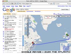
However, those clever people at Google have come up with another suggestion. Using Google maps I requested directions from my home here in England, to my first destination within the US. Microseconds later the familiar Google maps screen appeared complete with a line from point A to point B. The map appears to take me first to france and Google calculates that the entire 3991 mile journey will make me “about 29 days and 10 hours.”
So how come the Google has sent me first to france? And how come the journey which really shouldn’t take more than about 12 hours in total is going to take me nearly a month? For the answer to that question scroll down the Google directions (below) paying particular attention to point number 31.
—


Wrote the following comment on Jun 27, 2007 at 12:30 pm
LOL!!!! :-D
I love it that people at Google have a good sense of humor.
Wrote the following comment on Jun 28, 2007 at 7:25 pm
yay for google! i think i tried the same when i came to england in march. I also just tried antarctica and greenland, and some other south american countries but they didnt compute. Maybe its just an england us thing.